

That smartphone in your pocket has a GPS that can be used to track your hikes. Easy.... really. In this post, I'll show you how to take advantage of free apps that will give you "credit" for every step you take outdoors, even mowing the yard or walking around your neighborhood. If you're like me, keeping track of all the miles you walk will give you a sense of accomplishment and motivation.
 Dakota gets a tummy rub on the deck
First off, here's Doctor Walt's prescription for motivated hiking:
- Live in one of the most beautiful places in the world (CHECK!)
- Bring a dog with you. Or two.
- Listen to podcasts or audio books. My favorites are: Uncommon Knowledge, ID the Future, Dennis Prager, and Bryan Suits.
- Get a walking coach for a jumpstart.
- Use a free smartphone app to track miles on Android. Or Endomondo for iPhone.
This post will show you how to set up #5 with zero cost and zero distraction during your hike. I'll use Android's "My Tracks" app as an example but Endomondo for iPhone and many other hiking apps give you the same features. The My Tracks app is available from the Google Play Store for download.
Here's the My Tracks start-up screenshot. It shows previously stored hikes. Turn on your GPS, press the red circle and it will begin recording as you walk/hike/bike outdoors. The second screen has statistics, showing the total miles travelled, the time taken, and the speed.
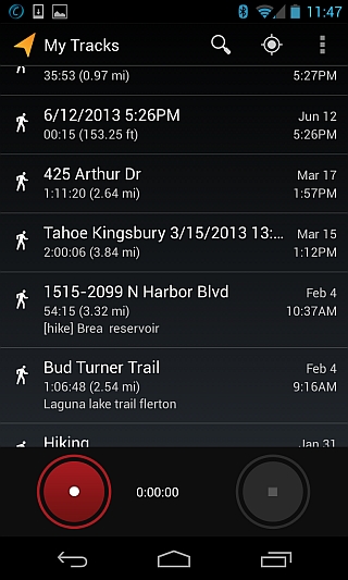 My Tracks log of previous hikes and recording this new hike.
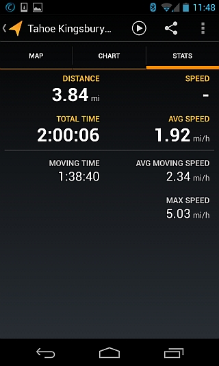 My Tracks statistics screenshot with speed and total miles travelled
Once the hike is over, press the Stop button (second grey circle above) and it will store away the entire route, map, and statistics. It keeps a map with a red line showing the route taken. No matter whether walking in cul-de-sacs, up driveways around houses, or on dirt trails, it accurately adds up the mileage.
When hiking in the mountains, vertical elevation makes a difference in the level of effort. The screen below shows vertical climbs and drops. Note the altitude starts at around 7400 feet and goes up.
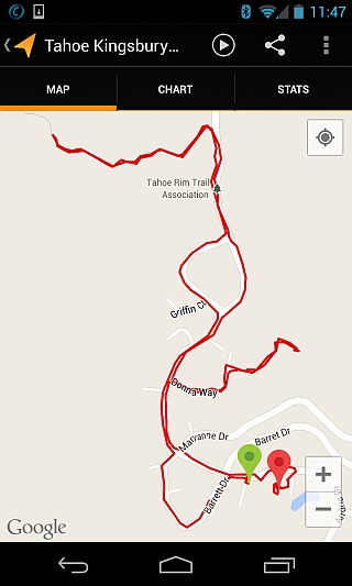 Map recorded after hike is done.
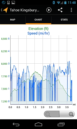 My Tracks chart of vertical elevation changes during hike
This particular hike is near the Tahoe Rim Trail and Castle Rock, in Stateline, Nevada overlooking Lake Tahoe.